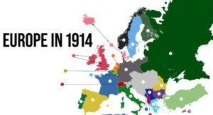
As part of his class “Europe after WWI,” Professor Andrea Di Stefano created an interactive assignment in which students looked at geographic and political changes to European countries as a key to understanding the effects of WWI, its aftermath, and role in other conflicts since that time. They created and annotated digital maps to show how the Treaty of Versailles redrew country boundaries and changed governmental alliances. Click here to see the work of Josh Laughren, a senior political science major.
Stefano designed this project through a vision with the Department of History and Global Studies and his colleagues Beth Purcell (’00), Dr. Kelly Elliott, and Dr. Joyce Haley (’04) in hopes that students could interact with the course material in a meaningful way. He then reached out to librarian Laura Baker (’87) in hopes of locating a specific map. After finding the appropriate content, the two decided to enlist the help of other departments in the library. The project grew, ultimately leading to a great collaborative work involving the Scholars’ Lab and Innovation Foundry in addition to librarian Laura and Dr. Di Stefano. In January, we will share the overarching process and all the moving pieces that came together to support exceptional learning at ACU.